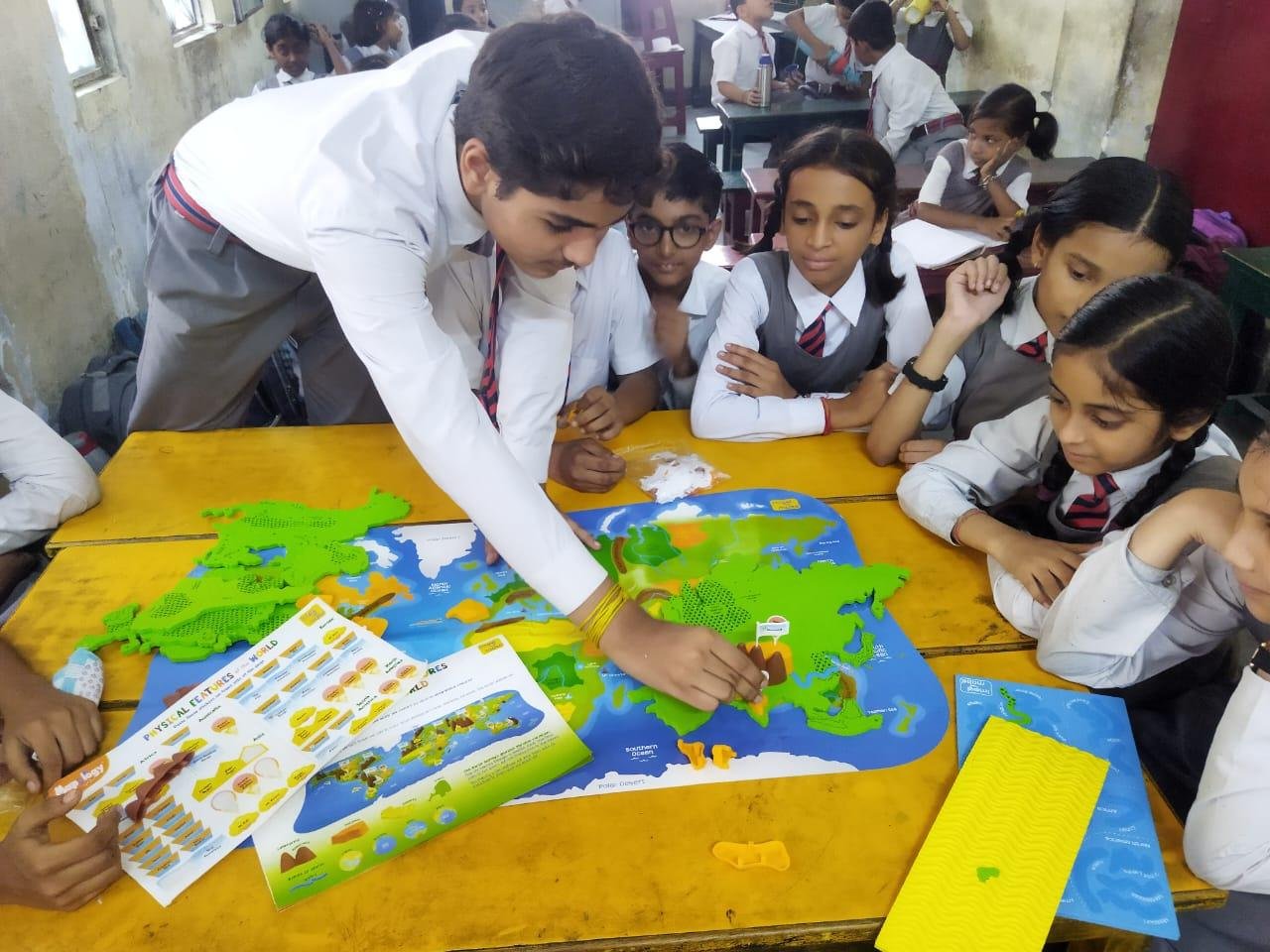
Digital navigation makes travelling easier, but children still need traditional map-reading skills. Discover how maps develop spatial thinking, direction sense, geographical awareness and practical problem-solving.
Why Children Should Learn to Read Maps in the Age of Google Maps
Imagine asking a child to find a nearby park without using a phone. Would they know which direction to take, how to recognise landmarks or how to understand the roads around them?
Today, digital maps and navigation apps have made travelling easier than ever. With just a few taps, children can see directions, estimated travel times and nearby locations. However, depending entirely on digital navigation can mean missing out on an important life skill: understanding maps independently.
Map reading is not just about remembering the names of countries, rivers and cities. It teaches children to understand their surroundings, recognise patterns, estimate distances and think about how different places are connected.
In a world where technology handles many everyday tasks, learning to read a map remains surprisingly valuable.
- Map Reading Develops Spatial Thinking
Spatial thinking is the ability to understand where things are located and how they relate to one another.
For example, when children look at a map, they begin to understand:
Which places are close to each other.
How roads connect different areas.
Why a river may pass through several towns.
How a small location fits into a larger region.
How directions change depending on their position.
These skills go beyond geography. They also help children understand diagrams, shapes, measurements and relationships in subjects such as mathematics and science.
National Geographic identifies spatial thinking as an important skill for learning geography and several other academic subjects.
- Children Become More Aware of Their Surroundings
Many children recognise places through shop names, buildings or familiar landmarks without understanding how those places connect.
A simple neighbourhood map can change that.
When children draw their route from home to school, they start noticing roads, crossings, parks, markets and other important locations.
This encourages them to observe their surroundings instead of simply following instructions.
Parents can make this activity more interesting by asking questions such as:
What is located between our home and the market?
Which road takes us to the nearest park?
Is the school north or south of our house?
Can you find another route to reach the same place?
These small exercises help children build a clearer understanding of their local environment.
- Maps Make Geography More Interesting
Geography can sometimes feel like a subject based on memorising names and locations. Maps make it more visual and practical.
Instead of only reading about India's states, children can locate them on a political map. They can trace major rivers, identify mountain ranges and understand how neighbouring states are connected.
They can also explore:
Physical maps showing mountains, plains and plateaus.
Political maps showing countries, states and boundaries.
Weather maps showing rainfall and temperature patterns.
Road maps showing transport routes.
World maps showing continents and oceans.
Different maps present different types of information. Learning to interpret them helps children understand that the same place can be represented in several ways depending on the purpose.
- Map Reading Connects Mathematics With Real Life
Maps offer an excellent opportunity to practise mathematics outside textbooks.
Children can learn about distance, direction, scale, measurement and basic calculations through simple activities.
For example, if a map uses a scale where one centimetre represents five kilometres, a child can estimate the distance between two cities by measuring the space between them.
They can also practise:
Comparing short and long routes.
Estimating travel distances.
Understanding directions and angles.
Reading coordinates and grids.
Calculating approximate journey distances.
These activities help children see how mathematical concepts are used in everyday situations.
- Children Learn to Think Independently
Digital navigation usually provides step-by-step instructions. A traditional map requires the user to understand the available information and decide what to do next.
Children have to examine the map, identify their location, compare possible routes and choose a suitable direction.
This encourages independent thinking and decision-making.
Of course, children should always follow age-appropriate safety rules when travelling. Map-reading practice should begin with familiar places and adult supervision rather than independent journeys.
- Understanding Maps Helps Children Explore the World
A map can introduce children to places they may never have visited.
They can explore the location of famous monuments, different countries, oceans, forests and mountain ranges. They can also understand how climate, transport, population and natural resources differ across regions.
For Indian students, this can make lessons about the Himalayas, the Thar Desert, the Deccan Plateau, coastal regions and major rivers easier to visualise.
Parents can even use a world map to show children where different countries are located when they read news stories or learn about international events.
- Digital Maps and Paper Maps Should Work Together
The goal is not to discourage children from using technology. Digital maps are useful tools, and understanding how they work is also important.
However, children should learn that digital navigation and traditional maps serve different purposes.
A digital map can provide live traffic updates and suggest alternative routes. A paper map can help children understand a wider geographical area without depending on a screen or internet connection.
Both formats can complement each other.
Parents can first introduce a location using a paper map and then show the same place on a digital map. Children can compare the two and notice how each presents information.
- Fun Map-Reading Activities Parents Can Try at Home
Children do not need complicated lessons to develop map-reading skills. A few simple activities can make learning enjoyable.
Draw a Map of Your Home
Ask your child to draw a simple map of their home. They can include bedrooms, the kitchen, the living room and other important spaces.
This teaches them to represent a real place from a different perspective.
Create a Neighbourhood Map
Take a blank sheet of paper and ask your child to mark familiar places such as the school, park, market and nearby roads.
Encourage them to use simple symbols and create a small map key.
Organise a Treasure Hunt
Hide a small object somewhere in the house and provide a basic map with clues.
Children can follow the map to locate the hidden object. This makes directions and symbols easier to understand.
Explore a Map of India
Choose a state and ask your child to locate its neighbouring states, major cities or rivers.
You can turn this into a family quiz and gradually introduce more challenging questions.
Compare Two Routes
Show your child two possible routes between familiar places. Ask which route appears shorter and what landmarks can be found along each one.
They can then compare their observations with a digital map.
- What Schools Can Do to Improve Map-Reading Skills
Map reading should not remain limited to textbook exercises. Schools can make geography more practical through activities that involve observation and exploration.
Teachers can introduce:
Classroom maps and school-layout activities.
Group projects based on Indian states and districts.
Direction and distance-based quizzes.
Map-making competitions.
Local geography observation tasks.
Activities using digital maps and satellite images.
Students can also create maps of their school, nearby community or an imaginary town. Such exercises encourage creativity while improving geographical understanding.
Frequently Asked Questions
- At what age should children start learning map reading?
Children can begin with simple maps of their homes and classrooms during the early school years. As they grow older, they can learn directions, map symbols, scales, grids and more detailed geographical information.
- Is map reading still important when children use Google Maps?
Yes. Digital navigation is convenient, but understanding maps helps children develop geographical awareness, spatial thinking and independent decision-making. Both traditional and digital maps have educational value.
- How can parents teach map reading at home?
Parents can begin with familiar places. Drawing a home map, locating nearby landmarks, exploring an atlas and organising simple treasure hunts are effective ways to introduce basic concepts.
- Does map reading help in subjects other than geography?
Yes. Map activities involve spatial relationships, measurement, scale, observation and visual interpretation. These concepts can also support learning in mathematics, science and history.
- What is the difference between a paper map and a digital map?
A paper map provides a fixed representation of a place, while a digital map can offer interactive features such as live navigation, traffic updates and location searches. Learning to use both helps children understand geographical information in different ways.
Conclusion
Technology has changed how people travel, explore and understand places. But knowing how to read a map is still a valuable skill that children should not miss out on.
It teaches them to look beyond a screen, understand their surroundings and make sense of the world around them. More importantly, it turns geography into something they can experience rather than simply memorise.
Parents and schools can bring this skill back through simple, enjoyable activities. Sometimes, a paper map and a little curiosity are enough to begin a meaningful learning experience.
 Online Learning
 Online Learning
 Online Learning